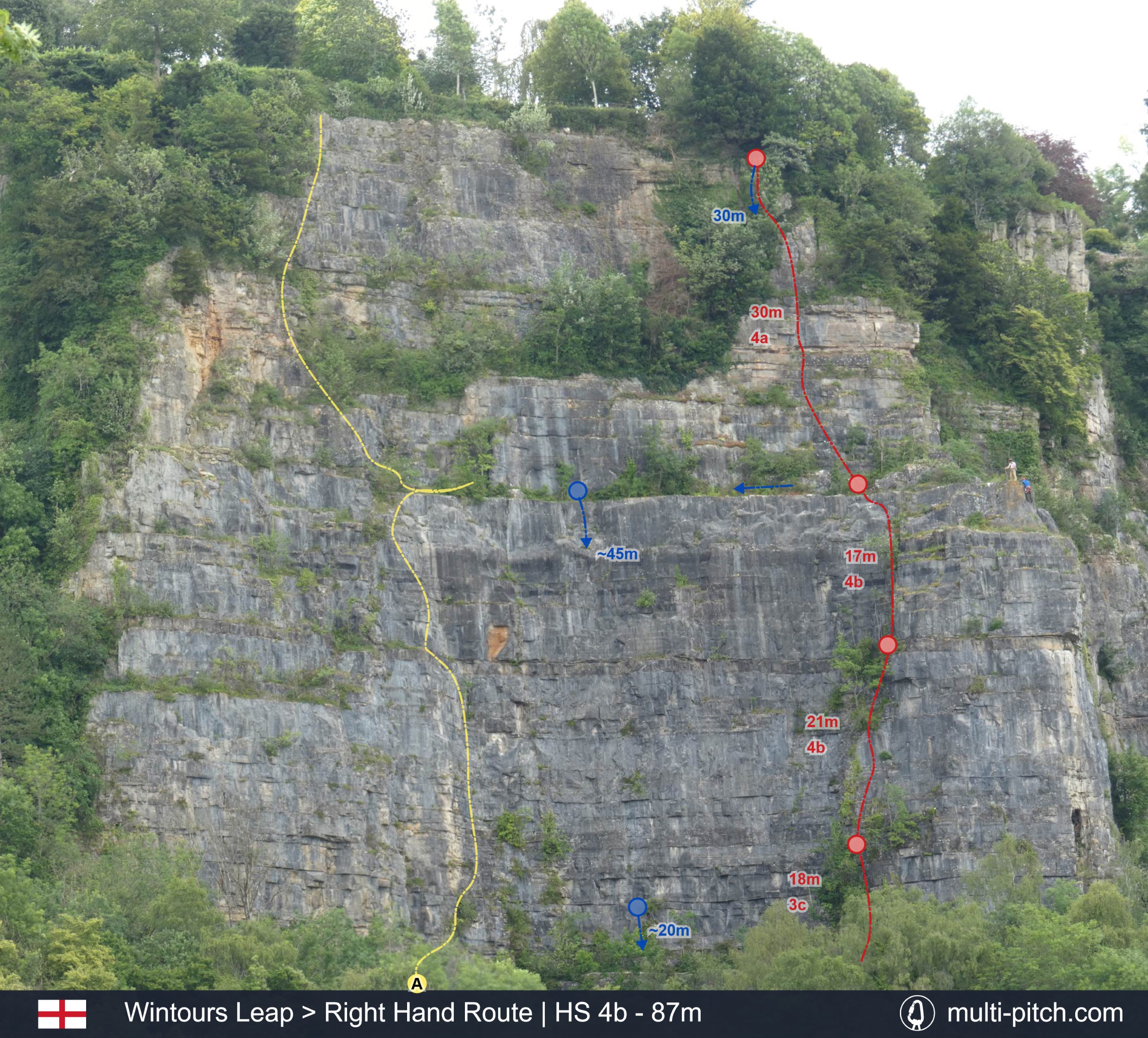
Wintours Leap - Right Hand Route
The right hand route is in many ways the opposite twin to the left hand route (also a Hard Severe climb). It has better pitches at the top where the left-hand route has better pitches at the bottom. While the right hand route looks heavily vegetated from the bottom it’s surprisingly clean. That’s not to say its perfect, just better than it looks. It has good variety and is more sustained in grade when compared to the left-hand route, which has a hard start and then eases off. It’s a classic limestone route with a small crack section, and exposed thin ledge system and a steeper juggy section at the end. Check the BMC RAD Database for route exit information (see references), but at the time of writing abseiling off is required (see descent info).
Required
The Route Topography
This is the route Right Hand Route on Wintours Leap in Gloucestershire, England. It represents 87m of Limestone rock climbing, usually over 4 pitches, of a max grade of HS 4b. Clicking the image will load the full screen high resolution Right Hand Route climb topo.
Original Image: our own image
Alternative Routes
A. Left Hand Route | HS 4b - 90m
The Left hand Route has a steep crux early on in the climb. This will be very hard for the technical grade (4b) for shorter climbers. As this section gets more polished over the years, it will only get harder if it isn’t already more of a 4c. This move and other points on the climb are protected by old pitons. It can also be backed up with a good nut/cam. After the crux the route eases. The second pitch heads up to a sapling tree followed by a couple of pitons then another small tree and limited gear for a bit of a run-out section, then some blocky ground before the Great Ledge. Although a great climb with varied interest up to the great ledge, the route is well polished and the pitches after the great ledge not very good and are quite vegetated. The original walk off exit at the top is not permitted anymore and abseil back to the ledge without crossing private property would be tricky. Therefore, finishing on the Great Ledge after pitch two or linking up the top of the Right Hand Route is the recommended way to send the North Wall of Wintour's Leap at the grade of HS.
Approach & Descent Information
Approach: There is a grassy parking space for several cars above the outcrop at 51.666565, -2.665006. From there, continue on the road you came in on and take the first obvious path left not long after leaving the parking area. Follow the path and take the next obvious left after the old stone arches. After following this path until you come to the old chapel near the river. Pass it and turn left at h the river. Follow this path for a short distance until you near the outcrop then take a left up a climbers path to the base of the cliff.
Descent: Following a change of ownership of the house above this section of crag, the previous arrangement to exit through its garden is not longer possible. Do not top out on any North Wall routes - only abseil descent from below the top of the crag is allowed. Trees and some abseil 'tat' allow climbers to return to the Great Ledge from the top of this climb. An abseil descent can then be made from one of the two bolted abseil stations above The Tap or Joe’s Route on the Great ledge. Climbers have reported being able to reach the base of the climb using a 50m rope abseil from the great ledge (maybe rope strech dependent). A 60m rope will allow a single abseil. There is an intermidate abseil point around halfway down the North wall. As always take care when abseiling and follow best practice (stopper knots, backup prussic and know how to ascend a rope if needed).
See Wintours Leap on the climb map Open climb location in Google Maps
Pitch By Pitch Information
The Right Hand Route takes a line up good rock, weaving around trees and foliage and makes good use of ledges for belay points.
Pitch 1 –18m 3c
Climb the cracked gully diagonally right to get around some bushes then cut back left above them. There is a small stance and a decent tree belay just above the main ledge. The tree can be backed up with some protection in the rock.
Pitch 2 –21m 4b
The second pitch ups the grade after an easy start. Climb straight up behind the belay past some vegetation. Keep moving up until you’re below a left leaning thin crack that leads to another small ledge with a tree belay (again back it up with the rock). The crack offers good holds and protection but can feel a bit exposed and is a slight step up in the grade, especially if you can’t find the good holds.
Pitch 3 –17m 4b
Climb up and slightly right onto some ledges. Take the left of two groves, this should have a peg you could use for additional protection. After that there should be a short neat slab and easier ground up onto the great ledge where there is a peg and tree belay at the back. Traversing left on a thin finger ledge before the great ledge offers a lovely if exposed climb with a big mantle move up.
Pitch 4 –30m 4a
A brilliant and rewarding pitch with great protection. Essentially you are looking to head though the broken V shape in the headwall above the ledge. The route has good holds, making it easer than it looks. After the broken V, climb the short wall above and then keep heading up to slings and an abseil ring set up on a tree. You can climb the chimney or the wall directly below the abseil and anchor point. Both are short but fun.
Guidebooks
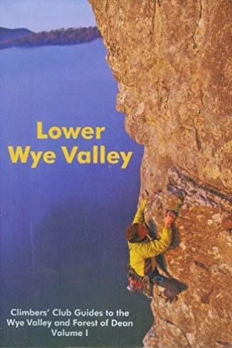
Lower Wye Valley - pg. 101
The guidebook Lower Wye Valley: Climbers' Club Guides to the Wye Valley and Forest of Dean has a good amount of information and climbs. The photos are, for the most part very clear. However, the way the book is organised makes it difficult to use. In true climber’s club style, there are no route numbers on the descriptions or page references on the photo topos, making it slow to find the details. When you do find the climb details, they use complex language and terminology, making it hard to understand. Unfortunately, there are not any other guidebook options for Wintour’s Leap. All things said, the guidebook is not too expensive a must for getting the most out of the area.
Availible Here
R.R.P. £ 25
ISBN: 9780901601797
Weather & Local Conditions
Seasonal Weather Information
Note that some weather stations are close or even on the mountain, others are in nearby towns. Plan accordingly!
Estimated Rainy Days Per Month
- 13
- 9
- 11
- 9
- 8
- 8
- 7
- 8
- 9
- 11
- 10
- 11
The graph shows the estimated average number of rainy days in the month that had more than 1mm rainfall or snow:
Estimated Temperature Per Month
- 71.6
- 7.31.5
- 9.62.8
- 12.74.9
- 167.7
- 19.210.7
- 20.712.2
- 20.212
- 17.710
- 14.17.4
- 9.74
- 7.92.5
Estimated average high and low temperature in degrees Celsius for the given month.
References & additional links
The following links will take you to external websites specifically related to this climb: Right Hand Route on Wintours Leap.
Note: They contained relevant information at the time of publishing.
Listed Nearby Climbs
The are some top quality multi-pitch rock climbs nearby. Guidebooks (see above) will have a more comprehensive list of other local climbing venues.

Morpheus on Avon Gorge
67m climb graded S 4a.
21.9km away
There are currently over 40 published multi-pitch climbs on the site.
View All Listed Rock Climbs